The Peninsular River System of India
The main water divide in peninsular India is formed by the Western Ghats, which runs from north to south close to the western coast. Peninsular rivers are much older than the Himalayan Rivers.
Most of the major rivers of the peninsular such as the Mahanadi, the Godavari, the Krishna and the Kaveri flow eastwards and drain into the Bay of Bengal. These rivers make deltas at their mouths. Numerous small streams are flowing west of the Western Ghats.
The Narmada and the Tapi are the only long rivers, which flow west and make estuaries. The drainage basins of the peninsular rivers are comparatively small in size.
There is a total of five River basin in the Peninsular Rivers in India such as the Narmada, Tapi, Godavari, Mahanadi and the Kaveri river basin.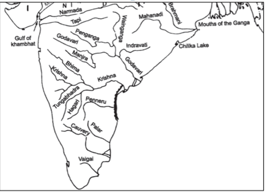
Rivers that drain into the Arabian Sea
The Narmada, the Tapi, the Mahi, Luni, Sabarmati flowing west as well as several small streams originating from the Western Ghats flow westwards into the Arabian Sea.
Rivers that drain into the Bay of Bengal
The Mahanadi, the Godavari, the Krishna, the Cauvery and several smaller rivers drain south-east into the Bay of Bengal.
River System in Peninsular Drainage.
Narmada River
- Narmada is the largest west flowing river of peninsular India.
- The Narmada rises in the Amarkantak hills in Madhya Pradesh. It flows toward the west in a rift valley formed due to faulting. On its way to the sea, the Narmada creates many picturesque locations.
- Its total length from its source in Amarkantak to its estuary in the Gulf of Khambhat is 1,310 km and drain into the Arabian Sea.
- It is bounded by the Vindhyas on the north, Maikala range on the east, Satpuras on the south and by the Arabian Sea on the west.
- The ‘Marble rocks’, near Jabalpur, where the Narmada flows through a deep gorge, and the ‘Dhuadhar falls’ where the river plunges over steep rocks, are some of the notable ones.
- All the tributaries at the Narmada are very short and most of these join the mainstream at right angles. Narmada basin extends over states of Madhya Pradesh, Gujarat, Maharashtra and Chhattisgarh.
Hydro Power Project in the basin:
Indira Sagar Dam, Sardar Sarovar Dam, Omkareshwar Dam, Bargi & Maheshwar.
Tapti River
- The Tapti (also known as the Tapi) is the second-largest west flowing river of Peninsular India and is known as ‘the twin’ of the Narmada.
- It originates near Multai reserve forest in Madhya Pradesh at an elevation of 752 m.
- Flows for about 724 km before outfalling into the Arabian Sea through the Gulf of Cambay (Gulf of Khambhat).
- The basin extends over states of Madhya Pradesh, Maharashtra and Gujarat having an area of ~ 65,000 Sq.km
- Situated in the Deccan plateau, the basin is bounded by the Satpura range on the north, Mahadev hills on the east, Ajanta Range and the Satmala hills on the south and by the Arabian Sea on the west.
Projects on Tapti River
Hathnur Dam of Upper Tapi Project (Maharashtra)
Kakrapar and Ukai Dam of Ukai Project (Gujarat)
Girna Dam and Dahigam Weir of Girna Project (Maharashtra)
Mahanadi River
- The Mahanadi basin extends over states of Chhattisgarh and Odisha and comparatively smaller portions of Jharkhand, Maharashtra and Madhya Pradesh, draining an area of 1.4 lakh Sq.km.
- It has its source in the northern foothills of Dandakaranya in the Raipur District of Chhattisgarh at an elevation of 442 m. It flows through Odisha to reach the Bay of Bengal. The total length of the river is about 900km.
- The Mahanadi is one of the major rivers of the peninsular rivers, in water potential and flood producing capacity, it ranks second to the Godavari.
- At Sambalpur, the Hirakud Dam (one of the largest dams in India) on the river has formed a man-made lake 35 miles (55 km) long.
- It enters the Odisha plains near Cuttack and enters the Bay of Bengal at False Point by several channels.
- Puri, at one of its mouths, is a famous pilgrimage site.
Godavari River
- The Godavari is the largest river system of Peninsular India and is revered as Dakshina Ganga
- The Godavari basin extends over states of Maharashtra, Andhra Pradesh, Chhattisgarh and Odisha in addition to smaller parts in Madhya Pradesh, Karnataka and Union Territory of Puducherry
- The Godavari River rises from Trimbakeshwar in the Nashik district of Maharashtra about 80 km from the Arabian Sea at an elevation of 1,067 m.
- The total length of Godavari from its origin to outfall into the Bay of Bengal is 1,465 km.
- The Manjra (724 km) is the only important right-bank tributary. It joins the Godavari after passing through the Nizam Sagar.
Krishan River
- The Krishna is the second-largest east-flowing river of the Peninsula.
- The Krishna Basin extends over Andhra Pradesh, Maharashtra and Karnataka having a total area of ~2.6 lakh Sq.km.
- The Krishna River rises from the Western Ghats near Jor village of Satara district of Maharashtra at an altitude of 1,337 m just north of Mahabaleshwar.
- The total length of the river from origin to its outfall into the Bay of Bengal is 1,400 km.
Tributaries of Krishna River
Right bank: The Ghatprabha, the Malprabha and the Tungabhadra.
Left Bank: The Bhima, the Musi and the Munneru.
The Bhima originates from the Matheron Hills and joins the Krishna near Raichur after for a distance of 861 km.
The Tungabhadra is formed by the unification of the Tunga and the Bhadra originating from Gangamula in the Central Sahyadri. Its total length is 531 km.
At Wazirabad, it receives its last important tributary, the Musi, on whose banks the city of Hyderabad is located.
Projects on Krishna River
The major Hydro Power stations in the basin are Koyna, Tungabhadra, Sri Sailam, Nagarjuna Sagar, Almatti, Naryanpur, Bhadra.
Tungabhadra is a major inter-States project in the basin, To operate the project and to regulate the flows among the beneficiary States of Karnataka and Andhara Pradesh.
Cauvery river (Kaveri)
- The Kaveri (Cauvery) is designated as the ‘Dakshina Ganga’ or ‘the Ganga of the South.
- The Cauvery River rises at an elevation of 1,341 m at Talakaveri on the Brahmagiri range near Cherangala village of Kodagu (Coorg) district of Karnataka.
- The total length of the river from origin to an outfall is 800 km.
- The Cauvery basin extends over states of Tamil Nadu, Karnataka, Kerala and Union Territory of Puducherry draining an area of 81 thousand Sq.km.
- The river drains into the Bay of Bengal. The major part of the basin is covered with agricultural land accounting for 66.21% of the total area.
Tributaries of the Cauvery River:
Left Bank: the Harangi, the Hemavati, the Shimsha and the Arkavati.
Right Bank: Lakshmantirtha, the Kabbani, the Suvarnavati, the Bhavani, the Noyil and the Amaravati joins from right
It is bounded by the Western Ghats on the west, by the Eastern Ghats on the east and the south and by the ridges separating it from the Krishna basin and Pennar basin on the north.
The river descends from the South Karnataka Plateau to the Tamil Nadu Plains through the Sivasamudram waterfalls (101 m high).
Projects on Cauvery River
During the pre-plan period, many projects were completed in this basin which included Krishnarajasagar in Karnataka, Mettur dam and the Cauvery delta system in Tamil Nadu.
Lower Bhavani, Hemavati, Harangi, Kabini are important projects completed during the plan period.